ExpertGPS: GPS Mapping Software with Aerial Photos and USGS Topo Maps
View your Lowrance, Magellan, or Garmin GPS waypoints and tracklogs and draw over Topo Maps and Aerial Photos with ExpertGPS desktop mapping software.
Seamless Aerial Photos and Topo Maps
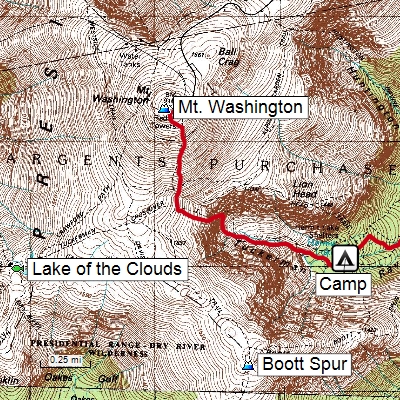
ExpertGPS is GPS map software for Windows computers, laptops, and tablets. View GPS waypoints and tracklogs from any handheld GPS receiver over aerial photos and US topographic maps. Plan your next outdoor adventure over scanned USGS topo maps and send a route directly to your GPS receiver to guide you in the field. View your GPS tracklog over an aerial photo to see exactly where you went.
ExpertGPS downloads aerial photos and topo maps for any location in the US, saving the maps to your hard drive. Disconnect your laptop and head out on a trip, and all of your data is available. ExpertGPS keeps track of which maps need to be retrieved from the Internet, so you can quickly define an area to map and let ExpertGPS gather the data later.
Learn more about ExpertGPS Mapping Software.
ExpertGPS Pro: layer your GPS tracks and waypoints over GIS data and seamless maps
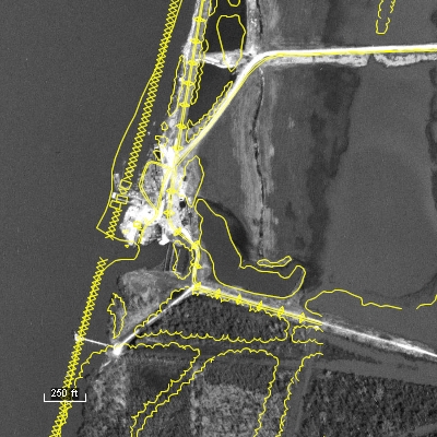
ExpertGPS Pro combines GIS layering with seamless mapping and one-click data transfers to any Garmin, Magellan, or Lowrance GPS receiver. Now everyone in your organization can view, query, and edit GIS layers and shapefiles directly over maps and aerial imagery. Transfer your GIS data to any handheld GPS receiver and print maps with data overlays for use in the field. Quickly import field-checked waypoints and tracklogs and merge them back into your GIS layers.
Learn more about the GIS to GPS software features of ExpertGPS Pro.
Combine your AutoCAD DXF drawings with data collected on any handheld GPS
The CAD/DXF Option for ExpertGPS Pro allows you to import AutoCAD drawings in DXF format and view them with seamless mapping and one-click data transfers to any Garmin, Magellan, or Lowrance GPS receiver. View your engineering drawings over topo maps and aerial photos, and combine them with field data collected with any handheld Garmin, Magellan, or Lowrance GPS receiver. Export your DXF drawings to Google Earth, and see them on top of the latest color imagery. Send boundaries and other CAD features to your handheld GPS for use in the field.
ExpertGPS Pro is a perfect tool for merging GPS-collected data with your engineering files. Preview your next job site on the maps in ExpertGPS, and map out a route to follow. Mark new features in the field as waypoints (or take photos with your digital camera) and when you return to the office, ExpertGPS will place them on the map automatically. Make any changes or add additional notes, and then export the data back to your engineering department in DXF format.
ExpertGPS allows you to paste formatted data from Excel or other tabular/CSV formats directly into the Waypoint List, making it easy to move AutoCAD or other data between your workstation and your GPS.
With an easy learning curve and a price your organization can afford, ExpertGPS Pro lets everyone in the office collect, view, and work with geospatial data. ExpertGPS Pro can manage your entire office's collection of Garmin, Magellan, Lowrance, and Eagle GPS receivers, giving you the mapping, GPS transfer, and spatial data entry tools you need to get your next job done in record time.
Learn more about the GPS to CAD software features in ExpertGPS Pro...
© 1998-2026 TopoGrafix – 24 Kirkland Dr, Stow, MA, USA
Get Help & Support for EasyGPS
Try ExpertGPS: Advanced Geocaching and Mapping Software with Topo Maps and Aerial Photos